


AFYON TRAVEL GUIDE
- AFORIA THERMAL RESIDENCES Aforia Thermal Residences, Afyonkarahisar, Afyonkarahisar 03032, Türkiye
- FRİG VADİSİ Frig Vadisi, Ihsaniye, Afyonkarahisar 03372, Türkiye
- MERYEM ANA KİLİSESİ Ayazini Kilisesi, Ayazini Köyü, Ihsaniye, Afyonkarahisar 03372, Türkiye
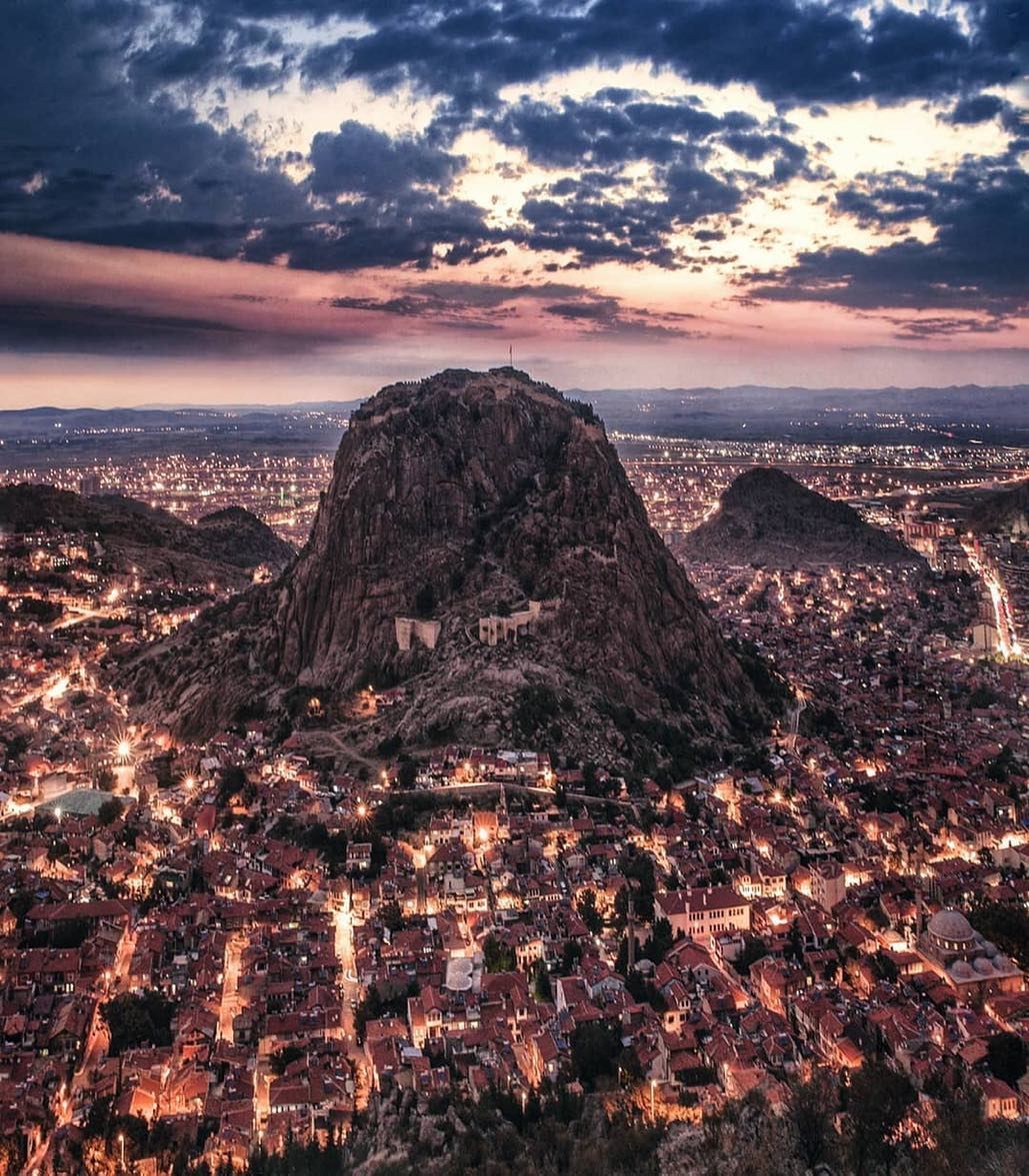
- KARAHİSAR KALESİ Karahisar Kalesi, Kale Mh., Afyonkarahisar, Afyonkarahisar 03100, Türkiye
- ULU CAMİİ Ulu Cami, Tacı Ahmet Mh. Ulucami Cd., Afyon, Afyonkarahisar 03100, Türkiye
- SULTAN DİVANİ MEVLEVİHANESİ Sultan Divani Mevlevihane Müzesi, Mevlana Mh. Zaviye Türbe Cd., Afyonkarahisar, Afyonkarahisar 03050, Türkiye
- TARİHİ AFYON EVLERİ Tarihi Konaklar, Afyonkarahisar, Afyonkarahisar, Afyonkarahisar 03100, Türkiye
- BEDESTEN ÇARŞISI Bedesten Çarşısı, Afyonkarahisar, Afyonkarahisar, Afyonkarahisar 03100, Türkiye
- KOCATEPE ANITI Kocatepe Anıtı, Afyonkarahisar, Afyonkarahisar 03105, Türkiye
HISTORY OF AFYONKARAHİSAR
Located in the inner parts of the Aegean Region, Afyonkarahisar is one of the coldest provinces in the region. The city, which has a history dating back thousands of years, is known to have hosted the Hittites in the early 2000s BC, and later the Phrygians and Lydians. In the late 6th century BC, the region came under Persian rule. Following the Roman and Byzantine periods, the Turks dominated this area towards the end of the 12th century. The name of the region was called Hapanuva during the Hittite period, and Akroinon during the Byzantine and Roman periods.
When the Anatolian Seljuk State was defeated in the Battle of Kösedağ, the Sahib Ataoğulları Principality, with its capital in Afyonkarahisar, was established in this region in 1275. The name of the city, with the title of Sahip Ata Fahrettin Ali, was formerly known as Karahisâr-ı Sahib. The word Karahisar was taken from the fortress located on the dark-colored volcanic rocks in the city.
In 1341, the Sahib Ataoğulları Principality joined the Germiyanoğulları Principality. After many events, this region came under Ottoman rule in 1429. The city's name was first mentioned in documents as Afyonkarahisar in 1684. The word Afyon was added because of the poppies grown in large areas in the region.
FRYGIAN VALLEY
Phrygia, which spreads over the geography between Afyonkarahisar, Ankara, Eskişehir and Kütahya, and the Phrygians, who had a remarkable civilization approximately 3000 years ago, are still among the legends that are traced today. The Phrygian Way, which was designed as a thematic cultural route and opened in 2013, consists of three main routes that include long walking and cycling paths at international standards and enables travelers to discover Phrygia.
The Phrygian Valley, which was established by the Phrygians (the oldest people in history according to the Greek historian Herodotus) who gave the region its name by carving houses, castles and monuments into the rocks 3 thousand years ago, is a very special geography that must be seen with its boundless beauty and untouched nature. The Phrygian Kingdom, one of the unique civilizations that left its mark on Anatolian history, has been the subject of many mythological stories. This valley, where the Phrygians lived for centuries, has also hosted different cultures and civilizations throughout history. Surrounded by Phrygian rock monuments and rock settlements, the valley also contains burial chambers and churches from the Roman and Byzantine periods.
Due to the easily processed volcanic tuff rock structure of the region and its geopolitical location, Ayazini was used as a settlement area by the Phrygians, as well as the Romans, Byzantines, Seljuks and Ottomans, who were the civilizations that shaped civilization.
Since the entire region consists of easily processed rock, shelters and castles for shelter purposes; and many churches and chapels due to their beliefs are seen. Recent investments contribute to the region becoming a center of attraction.
WELCOME THE FROST
& PROMOTION CENTER
For the first time in Turkey, the mysterious history of the Phrygians meets with today's technologies and is transferred to the future at the heart of Phrygia, the "Ayazini Reception and Promotion Center." With different and innovative digital systems, visitors have the chance to learn by experiencing information about the Phrygian Period.
The museum tour, which begins with an interactive screen describing the "Mysterious Civilization of the Phrygians", takes visitors on an impressive historical journey with a documentary film that sheds light on Phrygian history and was prepared for the first time in Turkey using artificial intelligence technology.
“All the settlement areas belonging to the Phrygians are revealed with the interactive map where documents and photographs belonging to the Ancient Cities and the King's Road are presented. In the following area, intriguing and striking information about the "Phrygian Culture and Mythology" meets the visitors with interactive wall technology and animations.
MARY VIRGIN CHURCH
The Virgin Mary Church, which is the most striking and rarely seen structure in the world in Ayazini, is also known as the Carved Church and Gavur Bath. The structure takes its current name from the monogram meaning "Mother of God" made in relief technique in the eastern section of the south narthex of the church.
The most important feature that distinguishes the structure from other rock-carved churches in Anatolia is the triple apse arrangement that can be perceived from the outside, and it is rumored that it overlooks Jerusalem. Inside this church, which is a historical and cultural wonder with magnificent acoustics, there are cross reliefs and inscriptions, and traces of the six collapsed legs of the columns can be seen.
The work dates back to the Byzantines and there are stamps belonging to Turkish tribes carved into the entrance corridor and narthex walls. The stamps, understood to belong to the Kayı, Afşar, Bayat and Eymir tribes, are living witnesses of the periods when Anatolia came under Turkish rule.
METROPOLIS STOREY LAYOUT
The settlement, which was carved into multiple floors, consists of small and large rooms. At first glance, there is a large room that looks like a hall, and on the right side of the room, there is a carved staircase in the rock leading to the upper floors. While the rooms on the left have vaulted ceilings and flat walls, the opposite has an oval form and there are holes in different forms on the floor. On the floor of the large space, there are wooden pole pits and silos, and on the walls there are beam holes and traces of screens related to the room organization.
THE GRAVE OF ASL
The tomb chamber, which has a monumental facade dating back to the Roman period, draws attention with its triangular pediment as a continuation of the Phrygian tradition. In the middle of the upper half of the pediment, there is a Medusa relief with an eroded surface.
On either side of the relief arch, there are two lions sitting facing each other. To the right of the entrance door, there is an incised cross with anchored ends in the form of a Latin cross. On either side of the arch, there are two Phrygian lion reliefs facing each other (antithetic). On the walls of the tomb chamber, there are three arcosolium (niched rock-cut boat tombs) and in the middle, there are two simple chamosorion (rock-cut boat tombs). In the center of the room, on the arcosolium tomb opposite the door, there are two lion reliefs facing each other. On the ceiling of the room, there is a crescent relief, and on the right inside of the entrance, there is a female relief, and on the left inside, there is a male relief. The presence of two lion reliefs facing each other, as on the exterior, indicates that the owners of the tombs had very special status.
AVDALAZ CASTLE
Avdalaz Castle is a multi-story settlement consisting of spaces carved into the rock mass rising above a slightly elevated terrain compared to its surroundings. The upper floors are accessed by stairs located on the rock, and to the right of the stairs lies a rectangular stepped cistern. The rooms on the floors are arranged in a chain, and there are also spaces carved into the form of mezzanine floors within the floors themselves. In addition, there are spaces carved for storing provisions within the floors, niches on the walls, and loopholes on some walls.
ASLANTAS TOMB MONUMENT
On either side of the doorway of the Aslantaş rock tomb chamber from the Phrygian period, there are two majestic lions standing up and a lion cub under their feet. Above the door, there is a mass resembling the tree of life and above it, a winged sun disk extending to both sides, made in relief. The fact that there are steps on the upper part of the cemetery suggests that ceremonies were held in front of the monumental tomb at certain times. It is thought that Aslantaş is the tomb of an important Phrygian king and was built in the 7th century BC.
YILANTAŞ
It is located on the west of Aslantaş, in the continuation of the same rocks. Since the monument has been destroyed, triangular ceiling beams can be seen. On the outside of the monument, a lion relief and a foot relief have survived to the present day. On the door, there is a relief of a snake with a Medusa head and two warriors attacking the snake with their spears on either side, but it is not visible today because it is under the overturned rock.
MALTASH TEMPLE
Kybele is an open-air temple with a triangular roof and a mihrab. At the back of the monument, there is a well and its covers, as well as an altar. It is thought that offerings were made to the Goddess Kybele in this area behind the monument.
DEMIRLI CASTLE
Demirli Castle, located in the northwest of Göynüş Valley within the borders of İhsaniye District, was first used in the Phrygian Period and continued to be used in the Byzantine Period. Various spaces were created and inhabited by carving the natural rock called the castle. Today, a large cistern with stairs filled with stone can still be seen. Right next to the rock called Demirli Castle, there is a necropolis area consisting of coffer-type rock-carved graves and rock-carved burial chambers.
ANCIENT KINGS ROAD
The total length of the 'Phrygian Way' or 'Ancient King's Road', one of the most popular cultural routes in Turkey, with a geological structure consisting of tufa rocks and mysterious traces of approximately two meters deep, thought to have been used as a trade route, is 506 kilometers. The route, which is a long walking and cycling route of international standards created for today's travelers to follow the traces of the Phrygians, was registered by the Ministry of Culture and Tourism in 1994.
LAKE EMRE
Lake Emre, located near the town of Döğer in the İhsaniye district, is a naturally formed lake whose area narrows or expands depending on the rainfall periods. The lake, which provides the opportunity to see many historical and natural beauties of the Phrygian Valley, is also a stopover for migratory birds.
While taking a boat tour on Lake Emre with the King Midas Ship, you can observe the Phrygian rock monuments around the lake and explore the region with a bicycle and ATV tour. In addition to these, it is also possible to enjoy a horse safari, hot air balloon flight and camping in Lake Emre.
MEMEC ROCKS
These are the ruins that have survived from the 8th-10th centuries AD to the present day, with Byzantine living spaces and chapels carved into the rocks. On the steep southern surface, churches, burial chambers and shelters were opened during the Byzantine period. The most important of these is the church space in the middle. The AROG film, which brings the Stone Age atmosphere to the audience, was shot in 2008 at Memeç Rocks in Döğer Town of İhsaniye. The unique structure of the Phrygian Valley was used to create a Stone Age feeling, and the caves, water wells and flat areas in the valley were included in many scenes of the AROG film.
ASLANKAYA TEMPLE
The southern face of a high rock, the Aslankaya Monument, which is a vertically cut temple facade, has two sphinxes (human-headed lions) opposite each other in the beam spaces of the triangular roof, and Cybele between two lions in a niche on the main facade. The main facade is decorated with geometric patterned reliefs. The two side faces of the monument have also been cut, and a roaring lion rearing up on two legs has been made on the north side. The monument has a special place among Phrygian rock facades with its unique door design and rich reliefs.
THREE ROCKS
There are Roman and Byzantine rock settlements, monumental tomb chambers, Roman tombs and water cisterns on the upper part of the rocks in and around Üçlerkayası village of İhsaniye district. Some of the multi-story rock settlements around the large rock mass that gave rise to the name Üçlerkayası have not yet been reached. In addition, the fairy chimneys and ancient roads seen in the area attract the attention of tourists.
KARAHISAR CASTLE
Karahisar Castle, which gave its name to the city, is one of the most important symbols of Afyonkarahisar. Karahisar Castle, which has been a great asset to the city throughout history with its strategic location at an altitude of 226 meters, has been an important position to be taken or taken shelter in for many states from Phrygians to Hittites, Romans to Byzantines, Seljuks to Ottomans. The castle, which has traces of the culture of the Phrygians who lived in Anatolia between 1200-700 BC, has places of worship dedicated to the Mother Goddess Kybele and four large cisterns at its summit.
It is said that Alaeddin Keykubat hid his treasures in this castle and, according to another rumor, Hz. Ali came to the castle with his horse Düldül and the horse's footprints still exist today.
Offering its guests a unique view of the city, Afyonkarahisar Castle fascinates with its magnificent appearance that defies the years.
HEAD RIGHT
The Ulu Mosque, built in Afyonkarahisar between 1272-1277 on 40 wooden pillars without hammering a single nail, still stands tall despite the passing of approximately 750 years, and has become a rare example of Turkish wood carving and stonework, as well as a symbol of aesthetics. A beautiful example of Anatolian Seljuk architecture with its wooden architecture and glazed brickwork with diamond-shaped bricks, the Ulu Mosque is among the few mosques in the world and is on the UNESCO World Heritage Temporary List.
SULTAN DİVANİ MEVLEVİ CONVENT
Afyonkarahisar Mevlevi Lodge, which has been the center of many important activities throughout history, is one of the important Mevlevi Lodges after Konya Mevlevi Lodge. Afyonkarahisar Mevlevi Lodge, which was founded in the 13th century and is one of the 15 Mevlevi Lodges that have the feature of "Asitane" (where one can perform the ordeal), was a very important center for Mevlevi Order, especially in the 16th century during the time of Sultan Divani, one of the seventh generation grandchildren of Hz. Mevlana. Sultan Divani is the most important person in Afyonkarahisar Mevlevi Lodge and his tomb is inside the Mevlevi Lodge. You can examine many objects such as wax statues of dervishes, their clothes, daily belongings, examples of calligraphy and musical instruments in Sultan Divani Mevlevi Lodge.
In addition, the tradition of Healing Ashura, cooked with 40 prayers in the Mevlevi lodges, started in Afyonkarahisar during the reign of Sultan Divani and this tradition still continues today.
NATIONAL BATH
It is one of the beautiful examples of Ottoman architecture. The north of the bath section is the men's section and the south is the women's section. It is a brickwork structure made of rubble and cut stone. The work, which was previously called "Gavur Bath" because it was built by Armenian masters, is now known as "Millet Bath". The historical bath was registered as an ancient work that needs to be protected in 1981 and was restored between 2003-2005. Millet Bath, where the bath culture is kept alive, where the cold, warm and hot sections, bath tools and equipment, bath customs, and culture, education and history come together, awaits its guests.
HISTORICAL OPEN HOUSES
The historical mansions, which are among the first settlements of Afyonkarahisar, are the most beautiful examples of traditional Turkish architecture and attract the attention of the guests with their colorful appearance, taking them on a journey into the past.
While the local people continue to live in the historical houses, which have taken on a colorful appearance today after being plastered with a special mortar made of straw, sand and soil with the wood carving art of the Ottoman period, some of them also serve as restaurants, cafes and boutique hotels.
GASTRONOMY MUSEUM
& CULTURE HOUSE
It is a three-story, adobe-wood structure with a stone base, bearing the characteristics of the late Ottoman architecture. The first floor of this structure is the Gastronomy Museum, where Turkish delight, sausage and poppy seed production rooms, old kitchen revival rooms and spaces related to daily life are located together.
The second floor of the building is the Culture and Art House, which is one of the first places you should visit to see the thousands of years of traditions and cultural characteristics of the city. Afyonkarahisar culture is brought to life with silicone sculptures in rooms decorated with various furniture and antiques.
The ground floor is the Agriculture, Animal Husbandry and Farrier Museum, where various farrier equipment such as oxen, heddles, horse ploughs, scarves, pitchforks and rakes are exhibited, including works used in the Seljuk and Ottoman States, in the early years of the Republic of Turkey and in some regions today.
IMARAT MOSQUE
The mosque, which forms the center of the Gedik Ahmet Pasha Complex, which consists of a mosque, a madrasah and a bathhouse, is the most important Ottoman work in Afyonkarahisar. It is also known as the İmaret Mosque. It was built by Gedik Ahmet Pasha, one of the viziers of Fatih Sultan Mehmet, in 1472 by the architect Ayaz Ağa. The structure, which is in the type of mosques with an inverted T plan (with side spaces and a zawiya) in the Early Ottoman architecture, has two consecutive domes covering the prayer area.
Its single-balcony minaret is decorated with fluted, spiral shapes, and the spaces between the flutes are covered with dark blue glazed bricks.
STONE MADRASA
It is a part of the Gedik Ahmet Pasha Complex, one of the most important works built in Afyonkarahisar during the Ottoman Period. The madrasah, which consists of a total of 26 domes, has a large rectangular courtyard in the east-west direction. The transition units of these domes are formed by Turkish triangles. The Taş Madrasah, which has the basic characteristics of Ottoman madrasahs with open courtyards and porticos, has porticos on both sides, seven cells on each side and a classroom in the east.
Today, in accordance with its historical mission, religious and scientific activities and the performance and revival of traditional Turkish Islamic arts are carried out in the madrasah. In the madrasah; courses in rosary, yemeni, felt, glass beads, horn comb, silver and mother-of-pearl embroidery, weaving, marbling, knife and wood carving are given by traditional handicraft masters.
HATTAT KARAHISARI TURKISH ISLAM
ARTS GALLERY
While the art of calligraphy, illumination and marbling are introduced in the gallery, the section on calligraphy consists of three sections: ''Today's Calligraphers'', ''History of Writing'' and ''Calligrapher Ahmed Karahisari''. In addition, a copy of the Mushaf-ı Şerif, originally in Topkapı Palace, written by calligrapher Ahmet Şemsettin Karahisari by Suleiman the Magnificent, is also displayed in the gallery.
BEDESTE MARKET
Previously, a covered bazaar was built by Mimar Sinan in 1550-1553 by Cağaloğlu Rüstem Paşa, but this covered bazaar fell into disrepair about a century after its construction. The current Hacı Bekir Tiryaki Covered Bazaar was built by a French architect and an Armenian master. The building, which opens to the street from four directions, has a main entrance in the south. The doors of the covered bazaar, which has six doors, are connected to each other by internal roads, and there are shops on both sides of the roads. These shops, which mostly work in haberdashery, have wool yarn, lace yarn, headscarves, muslin, fabric and all kinds of needlework materials. In addition, local clothes used in weddings, henna bags and covers can be seen.
27. Tashan
The historical Taşhan, built by Kadı Abdullah Efendi and yemeni craftsmen in the 17th century, has served the city's trade for many years. The renovation work of this impressive inn, which was completed in 2018 and was built with rubble stones on two floors, has shops selling local handicrafts in the lower section. You can find many products unique to Afyonkarahisar, from carpets to rugs, from paintings to ornaments. There are also workshops for felt and rosary masters, and marbling and ney artists.
UTKU ANITA
The Utku Monument has become the most important and well-known symbol of the city, being identified with the Alilik building and Afyonkarahisar Castle in the background. It was built by the Austrian sculptor Krippel in memory of the War of Independence and opened by İsmet İnönü on March 24, 1936.
The monument consists of two parts: the statue and the pedestal. The four faces of the pedestal are decorated with bronze reliefs depicting Atatürk, Turkish soldiers, the Turkish flag, İsmet İnönü, Marshal Fevzi Çakmak and Atatürk working together on a map, and a moment of conflict during the Great Offensive.
VICTORY MUSEUM
After Afyon was taken by the 189th Regiment of the 8th Division at 17:30 on 27.08.1922, this is the building where Mustafa Kemal Atatürk came to Afyon by car after descending from Kocatepe. At that moment, this building was declared the Western Front Headquarters. Commander-in-Chief Mustafa Kemal Atatürk, Chief of General Staff Marshal Fevzi Çakmak, and Western Front Commander İsmet İnönü stayed in separate rooms in this building and these rooms were reserved for them and arranged in their names. This building is the building where the plans for the Battle of the Commander-in-Chief on 30 August 1922 were made and the attack order was given.
AFYONKARAHISAR MUSEUM
The story of the Afyonkarahisar Museum, which has a very large collection from prehistoric times to the 20th century, dates back to the early years of the Republic. With the efforts of the Society of Lovers of Atika, founded in Afyonkarahisar in the early years of the Republic, the collection of ancient artifacts began in Taş Madrasa, and it became the official “Museum Depot” in 1931 and the Museum Directorate in 1933. The institution, which served as a mixed museum (Archaeology and Ethnography) in Taş Madrasa from 1933 to 1970, moved to its second service building in 1971.
The museum's indoor display is 5 stories high, and the works belonging to the Paleolithic, Neolithic, Chalcolithic, Bronze, Hittite, Phrygian, Lydian, Persian, Hellenistic Roman, Byzantine, Seljuk, Ottoman and Early Republican periods are exhibited in a successful display arrangement on a large area of 55 thousand square meters. The museum, which is the largest in the Aegean Region, is impressive with its magnificent architecture resembling the skirts of whirling dervishes and the approximately 50,000 valuable works it hosts, based on the fact that it is the second important center of the Mevlevi Order. The world-famous Kybele, Herakles and Zeus statues are also in this unique museum.
SUHUT ATATURK HOUSE
Hacıvelioğlu Mansion was used as the joint headquarters building of the Commander-in-Chief, General Staff, Western Front Command and 1st Army Command on 24-25 August 1922. Mustafa Kemal Pasha made the final preparations for the Great Offensive here and gave the order to cut off all communication between Anatolia and the outside world in this mansion.
The study room used by Mustafa Kemal Pasha in the mansion has been arranged in its original form. There is a divan in line with the window, a closet opposite, a desk, a wardrobe and a flowerpot-lamp stand in the room. There is also an exhibition of paintings on the first floor of the mansion, which is about the War of Independence.
VICTORY ROAD
The first headquarters of the Great Offensive, a significant part of which took place within the borders of the Commander-in-Chief Historical National Park and resulted in victory, was established in Kocatepe. The path followed by the command group, Commander-in-Chief Gazi Mustafa Kema Pasha, Marshal Fevzi Pasha and İsmet Pasha, who moved from Çakırözü village of Şuhut district of Afyonkarahisar province to Kocatepe on the night of August 25-26, 1922, was re-projected as the "VICTORY ROAD".
KOCATEPE MONUMENT
Kocatepe is the place where the Great Offensive, which ensured the liberation of Anatolia and the Turkish Nation, was launched, directed and commanded by Commander-in-Chief Mustafa Kemal on August 26, 1922.
It is located on Kocatepe with an altitude of 1874 meters, 8 km above the town of Kocatepe (Büyükkalecik), 20 km south of Afyonkarahisar.
In 1953, a monument made of cut stone was built in Kocatepe, one of the cornerstones of the War of Independence, by the Ministry of National Defense, and a marble inscription with flower reliefs was placed on it. In 1993, the Ministry of Culture built the Atatürk Monument and landscaping, and opened it to visitors.
26 AUGUST MARTYR CEMETERY
It was built in memory of Lt. Col. Agâh Efendi and 100 Mehmetçik who defended the Kalecik and Kurtkaya regions, which were the only passage points to Kocatepe, where the Commander-in-Chief Headquarters was located, at the cost of their lives and did not allow the enemy to pass and were martyred.
İSTİKLAL PROMOTION CENTER
The Independence Promotion Center is a panoramic museum that was established to instill the consciousness and spirit of how the homeland was won in future generations, and tells the story of the Great Offensive and the War of Independence. The aim of the three-dimensional modeling of the monuments and important structures in the relevant places on the model is to provide visitors to the promotion center with a better understanding of the Great Offensive and to tell it realistically. The Independence Promotion Center is located on the route where the Greek Army tried to retreat towards Dumlupınar after the 26-27 August Battles, where the most violent clashes took place.
COLONEL RESAT
ÇİĞİLTEPE MARTYRDOM
It was built in memory of the 57th Division Commander, Colonel Reşat Bey, who committed suicide on August 27, 1922, out of sadness at not being able to keep his promise to Commander-in-Chief Gazi Mustafa Kemal Atatürk, and the martyrs in that area.
GIRESUNLULAR MARTYRDOM CEMETERY
The Greek army that occupied our country was positioned in the “Kabaçkırar” and “Dedesivrisi” positions within the borders of Doğanlar and Karaağaç villages of the district. During the war, 14 Giresun soldiers were martyred when the Greeks noticed the approaching Turkish soldiers and rained bullets on them. Ahmet Halis, who went down to Doğanlar village to bring water to his friends, saw that 14 of his friends were martyred when he returned with the water canisters in his hands. The martyrs were buried where they were, amid prayers and tears. After an attack that lasted 36 hours, the Giresun soldiers succeeded in pushing the enemy out of the Dedesivri position.
After the War of Independence ended, Ahmet Halis Asal, a member of the Giresun Veterans Association, came to the Doğanlar village in 1964 to visit the areas where they fought and to visit the graves of his friends, and decided to build a cemetery for his friends. Ahmet Halis Asal, who made a will saying, "When I die, bury me next to my martyred friends. Do not separate me from my martyred friends," died in 1977 and was taken from Giresun to be buried next to his friends in the Giresunlular Martyrs' Cemetery as the 15th person.
MORE ABOUT AFYONKARAHISAR
TO HAVE DETAILED INFORMATION